Sussex Military Research Projects
Your search returned 37 results
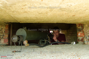
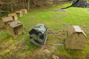
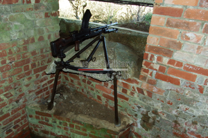
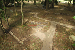
Pillbox survey
Project ID: SMR1051
Location: Cuckmere Haven, East Sussex
Project date: 2010
Images: 8
Filming for a TV documentary provided an opportunity to set up a Vickers gun in a pillbox and gain an interesting insight. [Read more]
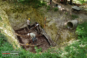
Auxiliary Unit Operational Base
Project ID: SMR1001
Location: Warningcamp, West Sussex
Project date: 2011
Images: 45
In 2011 a very rare opportunity arose to conduct an excavation of a 1940 Auxiliary Unit Operational Base (OB) at Warningcamp. [Read more]
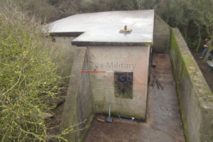
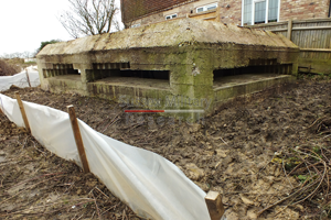
Newhaven Battery Plotting Room
Project ID: SMR1002
Location: Newhaven, East Sussex
Project date: 2012
Images: 28
Removal of vegetation from and recording of, the Battery Plotting Room (BPR) for the coast artillery battery on West Hill, Newhaven. [Read more]
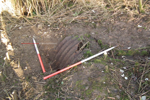
Weapon pit
Project ID: SMR1036
Location: Newhaven, East Sussex
Project date: 2012
Images: 4
Partial excavation of an infantry slit trench sited for the defence of the Battery Plotting Room at Newhaven. [Read more]
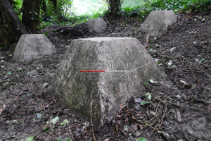
Anti-tank blocks
Project ID: SMR1003
Location: Cripp's Corner, East Sussex
Project date: 2014
Images: 33
Removal of vegetation from two groups of anti-tank blocks in the vineyard and design of an interpretation board. The foundation of one of the blocks was excavated. One was also painted with a camouflage scheme as described by archive documents of 1940. [Read more]
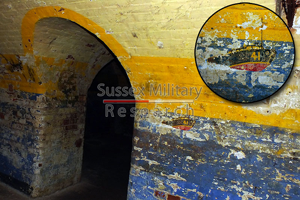
Newhaven Fort counterscarp galleries
Project ID: SMR1020
Location: Newhaven, East Sussex
Project date: 2013
Images: 16
The counterscarp galleries at Newhaven Fort are seldom seen by the public due to difficult access. A series of rooms in this area were used during and after the Second World War by the air/sea rescue units operating out of Newhaven Harbour. A series of colourful murals was painted just after the war, of which a basic photographic survey was undertaken. [Read more]
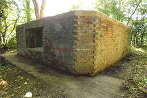
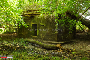
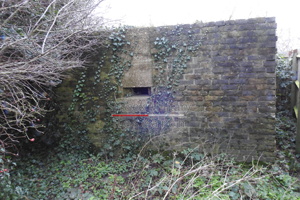
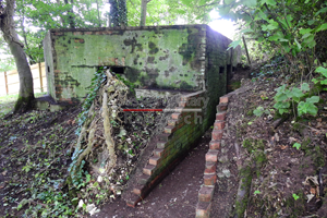
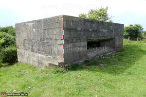
Type 28 Pillbox (A40)
Project ID: SMR1004
Location: Blackham, East Sussex
Project date: 2013
Images: 24
Pillbox serial number A40 was designed to acommodate a 6-pounder gun covering a nearby bridge over the River Medway. In the event, a gun was never mounted here. Standing in the corner of a field, the site was heavily overgrown and subject to seasonal deep flooding. [Read more]
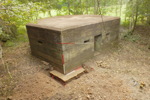
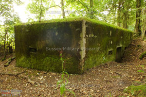
Type 24 Pillbox (A38)
Project ID: SMR1034
Location: Blackham, East Sussex
Project date: 2013
Images: 15
This pillbox does not have an identification number painted on its blast wall, but based on the numbers of the surrounding pillboxes, it is presumed to be A38. The pillbox sits on low ground and is susceptible to flooding up to a metre deep when the River Medway bursts its banks. [Read more]
Type 24 Pillbox (A34)
Project ID: SMR1043
Location: Blackham, East Sussex
Project date: 2013
Images: 22
This pillbox is one of a pair that were sited close together for mutal defence. A34 sits on the flood plain by the River Medway, while its neighbour, A35, is on high ground overlooking it. These pillboxes were worked on concurrently, a key task being to clear vegetation from between them, thereby putting them back into context with each other. [Read more]
Type 24 Pillbox (A35)
Project ID: SMR1044
Location: Blackham, East Sussex
Project date: 2013
Images: 22
This pillbox is one of a pair that were sited close together for mutal defence. A35 is on high ground overlooking its neighbour, A34, which sits on the flood plain by the River Medway. These pillboxes were worked on concurrently, a key task being to clear vegetation from between them, thereby putting them back into context with each other. [Read more]
Battle pillbox and dragon's teeth
Project ID: SMR1006
Location: Battle, East Sussex
Project date: 2017
Images: 1
Description: Excavation on private land at Battle of elements of the anti-invasion defences of 1940. A series of concrete anti-tank obstacles (known as dragon's teeth) were cleared of vegetation. [Read more]
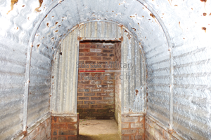
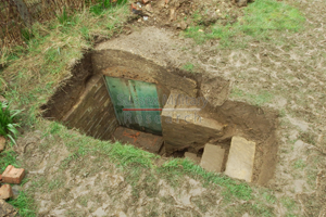
Air Raid Shelter
Project ID: SMR1005
Location: Storrington, West Sussex
Project date: 2014
Images: 10
A privately-manufactured air raid shelter incorporated into an ornamental garden pond post war. Partly buried below ground level, the shelter design was heavily influenced by the official government Anderson Shelter, but using alternative materials. Access was via a flight of steps covered by a porch. [Read more]
Anti-tank wall survey
Project ID: SMR1012
Location: Cuckmere Haven, East Sussex
Project date: 2015
Images: 22
As part of the Environment Agency's strategy of coastal management, shingle dredged from the mouth of the Cuckmere River was to be placed on the beach to prevent it from being washed back again. This entailed covering up part of the anti-tank defences built in 1940 in order to shore up the beach from behind, thereby protecting the feature from coastal erosion. [Read more]
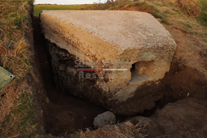
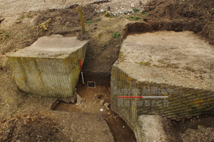
Pillbox excavation
Project ID: SMR1011
Location: Cuckmere Haven, East Sussex
Project date: 2015
Images: 49
Excavation and recording of a pillbox situated in a flood defence bank that had been damaged by previous (illegal) attempts to excavate it. The damage was restored by our reinstatement. [Read more]

Anti-tank block excavation
Project ID: SMR1028
Location: Cuckmere Haven, East Sussex
Project date: 2015
Images: 13
Excavation of a displaced and partly buried anti-tank block in order to record wartime graffiti from 1940. [Read more]
Pillbox survey
Project ID: SMR1026
Location: Cuckmere Haven, East Sussex
Project date: 2016
Images: 22
Survey, small excavation and set-up of machine gun to determine the use of a modification to the original pillbox design. [Read more]
Air Raid Shelter
Project ID: SMR1023
Location: Worthing, West Sussex
Project date: 2016
Images: 28
A privately-constructed air raid shelter based on the official Government Anderson Shelter. [Read more]
Anti-aircraft gun emplacements
Project ID: SMR1014
Location: Friston, East Sussex
Project date: 2016
Images: 1
Excavation and recording of two pairs of anti-aircraft light machine gun (AALMG) emplacements sited to defend Friston Airfield from low-level attack. [Read more]
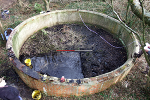
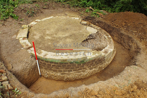
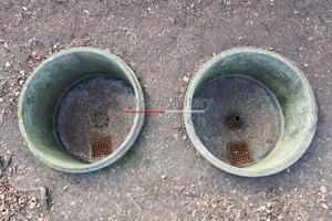
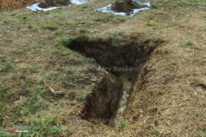
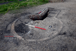
Emergency Water Supply (EWS) tank
Project ID: SMR1022
Location: Friston, East Sussex
Project date: 2016
Images: 1
Survey and partial excavation of a brick-built EWS tank for fire-fighting purposes near Friston Airfield. Graffiti etched into the render on the upper lip of the tank shows the tank was built in March 1944 and was therefore part of the preparations for Operation Overlord. [Read more]
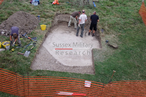
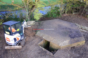
Pillbox foundation excavation
Project ID: SMR1027
Location: Cuckmere Haven, East Sussex
Project date: 2016
Images: 12
Partial excavation of a pillbox foundation visible as a parch mark near the A259 at Cuckmere Haven. [Read more]
Minefield fence excavation
Project ID: SMR1025
Location: Cuckmere Haven, East Sussex
Project date: 2016
Images: 6
Survey of a small area on the west side of the Cuckmere River adjacent to a Second World War minefield. [Read more]
Stone Cross pillbox
Project ID: SMR1008
Location: Stone Cross, East Sussex
Project date: 2017
Images: 26
This pillbox was originally scheduled for demolition as part of a new housing development, but was saved as a heritage asset following Grade II listing by Historic England. [Read more]
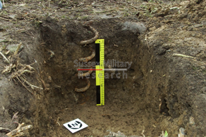
Slit trenches
Project ID: SMR1035
Location: Chailey, East Sussex
Project date: 2017
Images: 11
Chailey Common saw a lot of wartime activity resulting in the construction of a large number of earthwork defences including trench systems. [Read more]
Pillbox
Project ID: SMR1019
Location: Hoo, Kent
Project date: 2018
Images: 1
Basic external survey of a Type 24 pillbox at Hoo, built as part of the GHQ Line in 1940. A 3D model was constructed and used in an interpretation board to be displayed near a new housing development. [Read more]
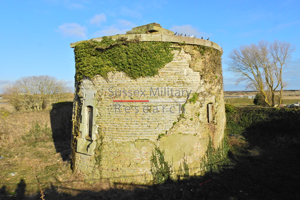
Martello Tower No.28
Project ID: SMR1018
Location: Rye Harbour, East Sussex
Project date: 2018
Images: 10
A partial survey focussing on internal features, the roof area and moat of Martello Tower No.28 at Rye Harbour. Built 1805-08 to meet the Napoleonic invasion threat, the tower was also occupied by the coastguard. During the Second World War it became an observation post and has an Ordnance Survey tertiary trig point installed on the roof. [Read more]
Sheffield Park Army Camp
Project ID: SMR1009
Location: Sheffield Park, East Sussex
Project date: 2018
Images: 30
Owned by the Soames family, parts of the grounds of Sheffield Park were requistioned by the War Office during the Second World War. In 1940 a tented campsite was established before being replaced by two hutted camps from early 1941. [Read more]
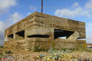
Shoreham Fort Spigot Mortar Emplacement
Project ID: SMR1010
Location: Shoreham, West Sussex
Project date: 2018
Images: 1
A partial excavation was undertaken of an unusual keyhole-shaped brick structure breaking the ground surface just west of Shoreham Fort. The fort had been occupied during the Second World War as a coast artillery battery and this feature is believed to have been a spigot mortar (anti-tank weapon) pit on account of its shape, dimensions and presence of a pedestal. [Read more]
Rye Harbour pillbox
Project ID: SMR1007
Location: Rye Harbour, East Sussex
Project date: 2018
Images: 24
A team of volunteers from Rye Harbour Nature Reserve and Sussex Military History Society spent a rainy November day cleaning out a pillbox at the mouth of the River Rother. [Read more]
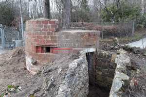
Pillbox
Project ID: SMR1017
Location: Kingstanding, East Sussex
Project date: 2019
Images: 1
Clearance of vegetation from, and a full survey of, a circular brick-shuttered pillbox dating to c1942 at the site of the Aspidistra transmitter used for (amongst other purposes) black propaganda radio transmissions. Traces of a 3-tone camouflage paint scheme were found on the brickwork. [Read more]
Anti-tank pimples
Project ID: SMR1016
Location: Bexhill, East Sussex
Project date: 2019
Images: 10
Permission was sought from two landowners to remove vegetation from and record a series of concrete anti-tank obstacles known as pimples on both sides of a road in Bexhill. A roadblock had been sited across the road in 1940 and the pimples were cast on the verges to prevent vehicles from bypassing the block. [Read more]
Type 24 Pillbox
Project ID: SMR1013
Location: Piddinghoe, East Sussex
Project date: 2019
Images: 17
A landowner clearing vegetation in 2019 uncovered a Type 24 pillbox forming part of the GHQ Line of pillboxes following the course of the River Ouse from Newhaven Harbour in 1940. A team of volunteers from SMHS spent a day removing dense undergrowth from the structure in order to facilitate recording. [Read more]
Pillbox
Project ID: SMR1030
Location: Undisclosed, (Protected site)
Project date: 2019
Images: 1
Vegetation clearance around a pillbox prior to recording. A tree surgeon carried out tree removal and minor landscaping to expose the structure. [Read more]
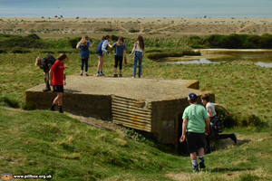
The School of Concrete
Project ID: SMR1050
Location: Cuckmere Haven, East Sussex
Project date: 2022
Images: 4
Sussex MR guided a group of young enthusiasts around Cuckmere Haven, highlighting the military use of the area from Napoleonic times. [Read more]

Rye Harbour pillbox B7/1
Project ID: SMR1052
Location: Rye Harbour, East Sussex
Project date: 2022
Images: 11
In May 2022, we set out to clear the build-up of beach shingle from pillbox B7/1 at the harbour mouth, furthest away from the Discovery Centre. [Read more]
'Pillbox Corner'
Project ID: SMR1053
Location: Winchelsea, East Sussex
Project date: 2022
Images: 20
On a bend in the Winchelsea - Rye road stands a Second World War pillbox. Known locally as Pillbox Corner, the structure is on private land. The interior was filled with compacted soil that had built up over 80 years; in June 2022, our team of volunteers set out to clean it out. [Read more]

Revealing Camber Castle
Project ID: SMR1054
Location: Rye Harbour, East Sussex
Project date: 2022
Images: 19
In July 2022 we spent a very hot day working in Camber Castle! We had a good turnout of volunteers working on two tasks, namely to clear part of the courtyard of vegetation and locate and record graffiti etched into the walls through the ages. [Read more]
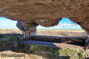
Pillbox excavation
Project ID: SMR1056
Location: Rye Harbour, East Sussex
Project date: 2023
Images: 30
This ruined pillbox stands on private land on the beach at Rye Harbour, but what is its story? Why is it so badly damaged? Sussex Military Research teamed up with the Rye Harbour Nature Reserve's 'Discover Rye Harbour' history group volunteers to try and find out. [Read more]